
Rule #7
US
en
Followers
77.2kAverage Views
199.6kEngagement Rate
3.7%Performance
Related Profiles


Here's the latest on Tropical Storm Debby
100.1k
1.48%
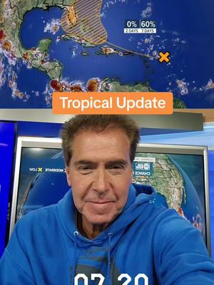
Here's your updated tropical outlook for Thursday.
158.3k
1.4%

Models are beginning to agree on a track for our Orange Blob.
68.1k
1.68%
Tuesday evening update on the "Orange Blob".
57.4k
1.31%
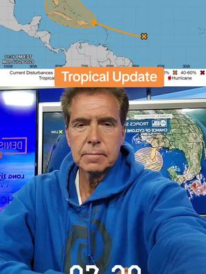
Tropical thoughts on "Orange Blob".
51.6k
1.61%


Here are my thoughts for Saturday, July 27th.
20.0k
2.84%

I know this is a big ask, but after the hurricane season we've had, is any area willing to step up and "take one for the team"? I'm thinking someone in the Midwest or Plains? Omaha? Topeka? Sioux Falls? Just asking...
33.5k
0.89%

Up to 70%. Looks like there's a good chance we have Sara by the end of the week. Still WAY too early to pinpoint intensity and location, but we'll need to keep an eye on it. GFS ensembles show a broad range of possibilities as you'd expect 8 days out.
15.5k
0.29%

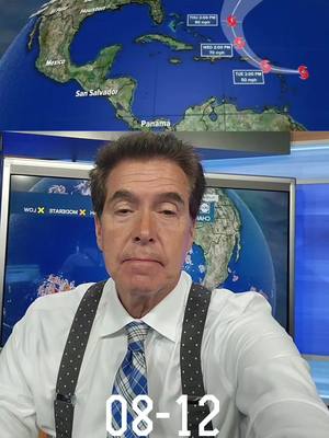
And...he's in Port Richey. 😳 (My bet is he ends up moving North)
549.8k
0.3%

"Quick" Afternoon thoughts: 1. We now have Tropical Storm Helene. Outside of that, absolutely nothing has changed from this morning. Check out my previous posts for my thoughts. 2. It ALL boils down to where this low is once it enters the Gulf. The steering currents are pretty much locked down. We said this yesterday. If the center is over the tip of the Yucatan tomorrow, the track should go more Panhandle/Big Bend. If the center is midway between Cuba and the Yucatan the track would be more Big Bend toward the Nature Coast. If the center is over Western Cuba, a track closer to the Bay Area is likely. The conditions driving movement aren't expected to change much, so it's pretty much where it starts its trip across the Gulf that will determine landfall. 3. I posted hurricane prep information in a post below. It's a really useful list our family has come up with over the years. 4. Lastly for Florida State University, FAMU, University of Florida, and University of South Florida students, the current forecast brings significant winds to Tallahassee on Thursday. If families decide to evacuate, they should do so no later than Wednesday afternoon. The worst of the weather won't arrive up there until later Thursday. For Gainesville, Helene's current track will bring hurricane gusts, but the worst would be West of you. IF the track changes East, you could see more wind. That's something I'll be keeping a close eye on. I'll be updating 24/7 to help you make the best decision for you and your family.
276.7k
0.18%

Tuesday Tropical Thoughts: 1. PTC 9 is expected to be named Helene later today. Upper-level winds are keeping it from getting its act together so far, but eventually, it's gonna happen. So here's what I'm thinking. 2. Hurricane and Tropical Storm Watches are in effect for our area. Based on the current track, the closer you are to the coast, the more wind you will get. IF, and that's a big if, IF the storm follows the exact forecast track, we will see gusts of hurricane force along the coast and much less wind inland. If the storm goes more to the East, those numbers will be higher. As Floridians, I think we all know that is a possibility regardless of what the models say. We have seen it happen so many times before. So, my point is, do not get overconfident with a track that has low impacts on our area. It's simply too early for that. 3. Surge will be an issue for our area even if it DOES stay well offshore. Helene is forecast to be a sizeable storm and will push water this way. Yes, if the track is closer, the surge will be higher, but a surge of 5 to 8 feet is possible based on the current track. That is similar to Idalia in many places. It could be significantly higher if the track is closer to our area. It always boils down to "hide from the wind, run from the water". If evacuation orders are issued, please heed them. 4. The current track takes this major hurricane very close to Tallahassee. Remember, the heaviest winds are usually confined to a very small area...maybe 5 miles. So any adjustment to the track East would probably minimize the winds in Tally. Anyone considering bringing their kids home should do so today or early tomorrow. Florida State University and FAMU will see 100-plus mph winds if the current track verifies. University of Florida students would also have higher impacts if the storm goes more to the East and lower impacts if the current track is accurate. 5. I'm sure you sense my tone with this one. I want to believe the science. I want to believe the models. I want to rely on my experience with these things. But I've lived here 35 years, and we all know storms coming in from this angle can be very tricky. I do NOT want another Ian. Ft. Myers really didn't see it coming because of the late change in track. Let me be clear, I am NOT saying that will happen with us, but I want to be darn sure that you're prepared for whatever comes this way. If the current track is correct, that's 65 ish sustained winds along the coast and much less inland. But if that track goes 50-100 miles more to the East, it's a completely different ballgame. Just be prepared, that's all I'm saying. Take it seriously. 6. You have 2 full days to get ready. If the NHC track is accurate, we'll be just fine with wind. Yes, there will be power outages, but nothing we haven't seen numerous times. The surge is an issue, and nowadays, that's a real thing. Again, the surge ONLY impacts people on the water. Surge is NOT rainwater...it's Gulf water. 7. Rule #7. This is definitely NOT the time to freak out. It's the time to prepare for whatever comes this way. I will post my prep suggestions again this morning in case you missed it yesterday. If the forecast is close to being accurate, (and there is no meteorological reason to think it won't be) the Bay Area will be ok. If there is a change to the track, we'll give you as much time as humanly possible to react accordingly. As for the panhandle and Big Bend, take this one seriously. This could very well be Idalia Part 2.
182.4k
0.34%

Latest Euro ensembles still show a very broad spread of possibilities next week. Don't go down the rabbit hole of focusing on operational worst case scenarios. They've been pathetic this year. 🎯
136.9k
0.13%
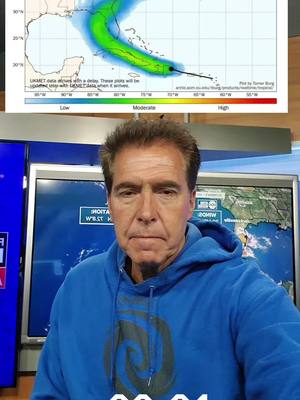
Here's the latest on Tropical Storm Ernesto
116.7k
0.35%
start an influencer campaign that drives genuine engagement


Technology
Fastest Growing